
- Local Guides Connect
- :
- Photography
- New tools for uploading Streetwiew images to Googl...
- Subscribe to RSS Feed
- Mark Topic as New
- Mark Topic as Read
- Float this Topic for Current User
- Bookmark
- Subscribe
- Mute
- Printer Friendly Page
03-16-2017 05:48 AM - edited 03-16-2017 05:59 AM
New tools for uploading Streetwiew images to Google Maps
Hi Guys This is not Spam but helpful information (please do not delete this post)
The new API allows now Third party Programmers
to create small miracles that helps New Trusted Photographers and Local Guides
to Edit Metadata, GPS and upload Photosphere from Mac and PC desktop
Now it becomes easy and precise to work as local Guide on Google Maps
leaving the mobile Street View app far behind.
Pano2VR 5.2 beta features the new Google Street View Export.,
it have integrated the export as part of the software.
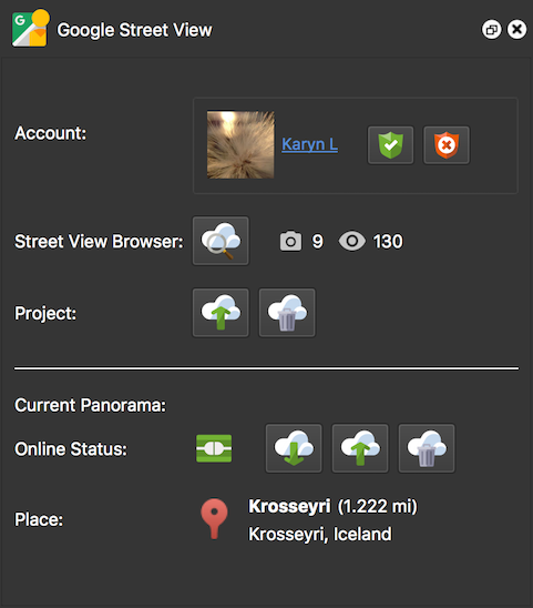
Google Street View Panel
Open the Street View Panel from the Toolbar, connect your Google account and upload your project directly to Street View.
To add connections just add hotspots to link the panoramas.
Improved Map View
You can now see linked nodes and you can also create links (hotspots) directly in the map.
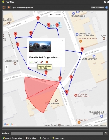
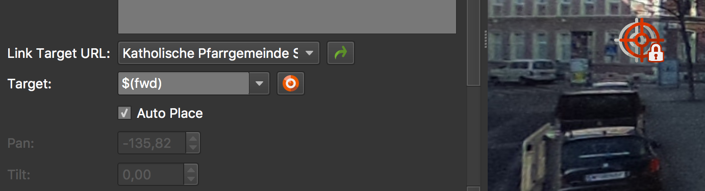
Map in Pano2VR 5.2 Auto Place Hotspots
In the Hotspot Properties panel, you will see a new option called, Auto Place. When this is selected, the hotspot is automatically positioned in the correct location of the linked panorama
Auto Place
Set North
You can now set North by pressing N and dragging the panorama to achieve the correct
heading.
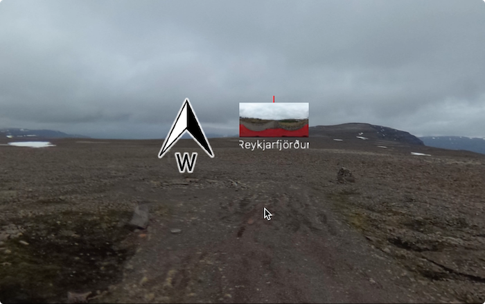
If you have connected hotspots in Pano2VR Pro, you will see a thumbnail of that panorama to help the guide placement.
Martin Hopkins Garden gnome software (alias Hopki) has created a video that shows the process below
- Mark as New
- Bookmark
- Subscribe
- Mute
- Subscribe to RSS Feed
- Permalink
- Report Inappropriate Content
03-20-2017 10:19 AM - edited 05-16-2017 01:56 PM
Re: New tools for uploading Streetwiew images to Google Maps
New Mini and Max Size on Google Maps are now 14 - 100 Megapixel
At least 14 megapixels (5,300 by 2,650 pixels) and at most 100 megapixels (14000 by 7000 pixels) with a 2:1 aspect ratio. In jpeg format.
72 and100MP Exambles https://goo.gl/maps/awbG6iu9Fks
Regards Svendus
- Mark as New
- Bookmark
- Subscribe
- Mute
- Subscribe to RSS Feed
- Permalink
- Report Inappropriate Content
03-25-2017 08:07 AM
Re: New tools for uploading Streetwiew images to Google Maps
- Mark as New
- Bookmark
- Subscribe
- Mute
- Subscribe to RSS Feed
- Permalink
- Report Inappropriate Content
03-25-2017 09:08 AM
Re: New tools for uploading Streetwiew images to Google Maps
@
yes it is not free It is a application for stunning Virtual tours and 360 Video
and the Street view function are mere an ad-on to the application
i am sure you have seen Pano2VR panoramas on the web
- Mark as New
- Bookmark
- Subscribe
- Mute
- Subscribe to RSS Feed
- Permalink
- Report Inappropriate Content
03-26-2017 06:23 PM - edited 03-26-2017 06:26 PM
Re: New tools for uploading Streetwiew images to Google Maps
I am not a coder, I avoid reinventing the wheel, but occasionally I do stuff to transform / link data in different formats and locations. I am very very tempted to see if I can use this API to make it easier to edit pitch, yaw and roll and upload.
My fingers are crossed that Hugin will follow where Pano2VR has lead. Perhaps I should join a Hugin forum to see what is going on, give encouragement.
- Mark as New
- Bookmark
- Subscribe
- Mute
- Subscribe to RSS Feed
- Permalink
- Report Inappropriate Content
04-13-2017 08:49 AM
Re: New tools for uploading Streetwiew images to Google Maps
If this is not spam, why you put a Facebook link and disguise it as a google map link.
Yes, I do hover all links before I click on them.
Naughty boy...
- Mark as New
- Bookmark
- Subscribe
- Mute
- Subscribe to RSS Feed
- Permalink
- Report Inappropriate Content
05-16-2017 06:13 AM - edited 05-17-2017 12:57 AM
Re: New tools for uploading Streetwiew images to Google Maps
i think your Facebook observation are incorrect
you might be answered another SvendN on this forum
please delete you message it is irrelevant
the images link come from our THETA 360 Developer forum
where the members can read and write
PatricL skrev:If this is not spam, why you put a Facebook link and disguise it as a google map link.
Yes, I do hover all links before I click on them.
Naughty boy...
- Mark as New
- Bookmark
- Subscribe
- Mute
- Subscribe to RSS Feed
- Permalink
- Report Inappropriate Content
05-16-2017 06:40 AM
Re: New tools for uploading Streetwiew images to Google Maps
It's not an observation, your link "72 and100MP Exambles https://goo.gl/maps/QJR51UrDhUM2" goes to.... Facebook
Min max limits without this tool is the same 14MP to 100MP. Google map link example.
No third party needed for this.
You might want to change your link to a proper one instead. have a good day!
- Mark as New
- Bookmark
- Subscribe
- Mute
- Subscribe to RSS Feed
- Permalink
- Report Inappropriate Content
05-16-2017 10:25 AM
Re: New tools for uploading Streetwiew images to Google Maps
@Svendus-Panorama thanks for sharing the information.
- Mark as New
- Bookmark
- Subscribe
- Mute
- Subscribe to RSS Feed
- Permalink
- Report Inappropriate Content
05-16-2017 02:02 PM
Re: New tools for uploading Streetwiew images to Google Maps
try this link https://goo.gl/maps/kYGnhkiR4gG2 my friend
PatricL skrev:It's not an observation, your link "72 and100MP Exambles https://goo.gl/maps/QJR51UrDhUM2" goes to.... Facebook
Min max limits without this tool is the same 14MP to 100MP. Google map link example.
No third party needed for this.
You might want to change your link to a proper one instead. have a good day!
- Mark as New
- Bookmark
- Subscribe
- Mute
- Subscribe to RSS Feed
- Permalink
- Report Inappropriate Content