
- Local Guides Connect
- :
- How-tos
- What to look for when taking accessibility photos
- Subscribe to RSS Feed
- Mark Topic as New
- Mark Topic as Read
- Float this Topic for Current User
- Bookmark
- Subscribe
- Mute
- Printer Friendly Page
05-17-2018
09:39 AM
- last edited on
08-22-2018
10:46 PM
by
Atsukot
![]()
What to look for when taking accessibility photos
One of the most helpful things we can do as Local Guides is add photos on Google Maps showing accessible places. These photos aid people with mobility issues in navigating places they want to go. As part of #LetsGuide, a celebration of everything that inspires us to share info as Local Guides, here are my tips for taking helpful photos that guide people with accessibility needs.
To start, keep in mind that some of the places you’d never think to photograph might be the most helpful for someone else. Consider hardware stores, grocery stores, and everything in between. Once you’ve settled on a spot, here’s what to keep in mind for great photos:

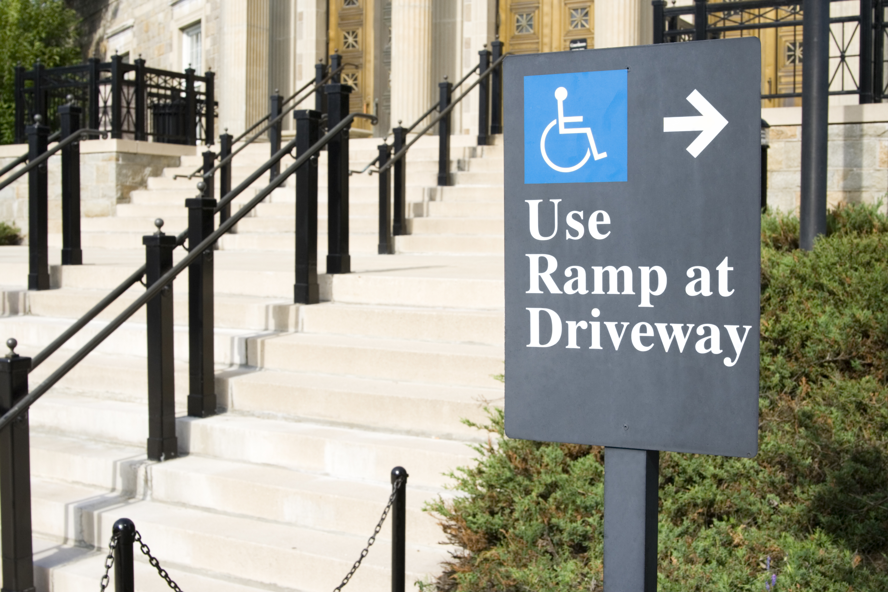
Tip 1: Look for accessibility signage
The easiest thing you can do when taking photos for accessibility is to look for signs. If you see signage noting a spot is accessible, photographing it is the first step in making sure someone knows that they might be able to go to that place.

Tip 2: If there’s no direct signage, look for other accessibility clues
Sometimes there isn’t clear signage about accessibility, but you can look for other clues about a place that might be helpful for others. Here are some things to look for and photograph: railings in restrooms, spacing between tables, and wheelchair-accessible ramps at entrances and exits. Use your photo’s caption to provide more details.

Tip 3: Make sure your photos clearly show the whole story
Shoot wider shots as well as tighter shots to give a full picture of how accessible a place is. Photos of signs up close are certainly helpful, but a wide shot showing as much of the location as you can will give somebody with accessibility needs a true feel for the spot, ensuring that they feel comfortable going to the place you’re recommending.
Are you somebody who uses accessibility info on Google Maps to make decisions about where to go? Tell everyone in the comments: What can other Local Guides do to help you know if a place is accessible?
- Mark as New
- Bookmark
- Subscribe
- Mute
- Subscribe to RSS Feed
- Permalink
- Report Inappropriate Content
05-17-2018 10:26 AM
Re: What to look for when taking Accessibility Photos
Thank you. Not about all I did know and wouldn’t remember. Very valuable.
- Mark as New
- Bookmark
- Subscribe
- Mute
- Subscribe to RSS Feed
- Permalink
- Report Inappropriate Content
05-17-2018 10:41 AM
Re: What to look for when taking Accessibility Photos
Yes, I agree with you . This is nice responsible.
- Mark as New
- Bookmark
- Subscribe
- Mute
- Subscribe to RSS Feed
- Permalink
- Report Inappropriate Content
05-17-2018 11:34 AM - edited 05-17-2018 12:04 PM
Re: What to look for when taking Accessibility Photos
Thanks for sharing this useful tips @AnnaDickson

![]() |
| ![]() |
| ![]() |
|  | Follow me on
  &
& ![]() |
| 
Please use '@' before the name to tag me.
- Mark as New
- Bookmark
- Subscribe
- Mute
- Subscribe to RSS Feed
- Permalink
- Report Inappropriate Content
05-17-2018 11:37 AM
Re: What to look for when taking Accessibility Photos
Hello @AnnaDickson Most inspiring content I'm agree with you...
- Mark as New
- Bookmark
- Subscribe
- Mute
- Subscribe to RSS Feed
- Permalink
- Report Inappropriate Content
05-17-2018 11:40 AM - edited 05-17-2018 11:41 AM
Re: What to look for when taking Accessibility Photos

- Mark as New
- Bookmark
- Subscribe
- Mute
- Subscribe to RSS Feed
- Permalink
- Report Inappropriate Content
05-17-2018 11:46 AM
Re: What to look for when taking Accessibility Photos
Thanks for sharing @AnnaDickson. These are very useful tips.
Hey @OSAMA Nice one photo you got there, thanks for sharing.
- Mark as New
- Bookmark
- Subscribe
- Mute
- Subscribe to RSS Feed
- Permalink
- Report Inappropriate Content
05-17-2018 11:48 AM
Re: What to look for when taking Accessibility Photos
Thank you @HelloSamsonR ,
Now i am really searching about accessablity entrances and routes ,
This program is life changing ....
- Mark as New
- Bookmark
- Subscribe
- Mute
- Subscribe to RSS Feed
- Permalink
- Report Inappropriate Content
05-17-2018 11:49 AM
Re: What to look for when taking Accessibility Photos
I will edit some of my reviews to add the detail again @AnnaDickson. I never cared of railings that are used in the buildings. I thought they are for normal purpose but just noticed they can be helpful for accessibility. Sometimes we remained unnoticed about a thing. I felt it now. A heartiest thanks for sharing this post Anna.
- Mark as New
- Bookmark
- Subscribe
- Mute
- Subscribe to RSS Feed
- Permalink
- Report Inappropriate Content
05-17-2018 11:50 AM
Re: What to look for when taking Accessibility Photos
@AnnaDickson, awesome tips, thanks for sharing useful article with us!
Sincerely,
Adrian
| Adriansyah Putera | Flickr |
- Mark as New
- Bookmark
- Subscribe
- Mute
- Subscribe to RSS Feed
- Permalink
- Report Inappropriate Content